Latest Journey (2023)

USA Trip: I'm Going to Hollywood!

Showing posts with label America. Show all posts

Saturday, 6 May 2023

USA Trip: I Made it to the Oscars and Hollywood!

Los Angeles, California

Academy Awards

The time was sprung forward by an hour, from 2am to 3am during my last day in Vegas for daylight saving. I lost one hour of sleep for my early bus to Los Angeles and  I am still living one hour short at the time of this posting. Even my Lyft driver wasn’t aware the time has been adjusted as she drove me to the bus pick up point and it wasn't a proper bus station. The instruction in the email was only mentioning about little green signage. Apparently I wasn’t the only who was unable to locate it as there was another couple looking for it, only to be told by another e-hailing driver that dropped off another passenger that it was on the other side of the road, slightly different than what being described. The bus departed almost on time as it started to head its way around half past eight and slowly Las Vegas was behind me. Quick stop at Barstow for lunch break after 3 hours, I safely arrived at Union Station shyly before 2.30pm.

Waiting for my bus. Booked my ticket via flixbus.com. It was a clear day, with Strat Tower in the distance.

Passing by this building as we left for LA. The venue for my first night show in Vegas.

It was Oscar’s Day when I arrived at Los Angeles, 12th of March. After settling down at my AirBnB, I started to walk towards Walk of Fame, whereby Dolby Theatre was located. It was 30 minutes walk from my place. Compared to the place I stayed in Las Vegas, the streets here I felt relatively safer, even at night as it was surrounded by busy neighbourhood, somewhere along North Vista Street and Santa Monica Boulevard. As I was approaching the venue, I could see there were police officers controlled the traffic, which was expected as evidently shown when I Google mapped earlier showing road blocks surrounding the building. The roads were fenced up and I found myself walking from one end to another just trying to get the good view of the red carpet. How silly of me thought that I could catch celebrities because apparently the show started at 5pm, the time I arrived at Hollywood Boulevard, which would mean the event would have been earlier. I guess I misread the 8pm time as the local time (Pacific Time) when it was actually Eastern Time. I could see a number of people was doing live, dressed up in tux as though they were hosting the show, outside the theatre. More like reporters. As the sky started to turn dark, I decided to leave and to have dinner at El Compadre. I believe this was about the same time when Michelle Yeoh was announced as the winner for Best Actress. Was so close yet so far but still feeling excited I was breathing the same air as hers as the historic moment happened.

My AirBnb In LA. Cozy. Would return to this place again should I am visiting LA.
Mural outside Hollywood Wax Museum. One of the alleys I used in getting to another street/avenue since Hollywood Boulevard was blocked.
Zoomed up to at least 9 times on my phone to capture this entrance. Was still naively waiting this time.
Next thing I know, people started to roll this carpet. Bummer.
Since I was already here, might just as well. Congrats, Dato' Michelle Yeoh!
Flaming Margarita: Saw this on Google Reviews so was very tempted to try.

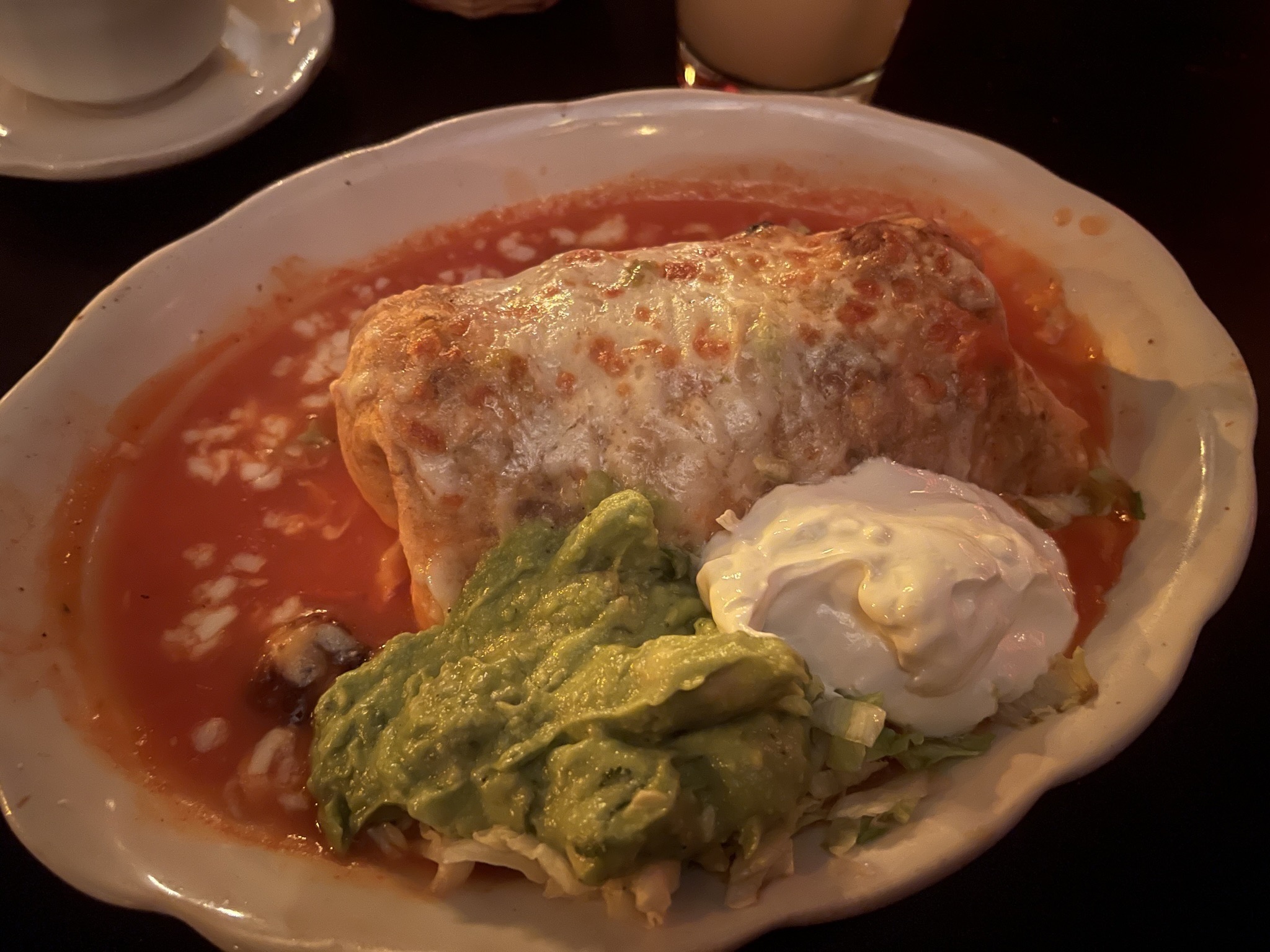
This portion of Burrito was so huge and I couldn't finish it.

Side note: As I was walking towards Hollywood Boulevard earlier, there was a group of people speaking Spanish right in front of me. They were pretty dressed up.  It was all normal until suddenly there was a guy in his car shouting "If you can't speak English, go back to your country!". That was the first and only racism that I encountered in the States.

Hollywood Sign Hike

Started my official first day in LA rather late to compensate the loss time I had the day before. The weather forecast indicated it would be partially cloudy and sunny so I decided to do Hollywood Sign hike on this very day.

Getting ready for the hike. Couldn't resist this standing mirror in my room.

Had my morning brunch at Blackwood Coffee Bar to fill up my energy bar, just enough to last till lunch hour. There were numerous trails getting to the sign and I made my way to Fern Dell Nature Trail as the starting point of my hike. It was a chilling stroll with lushes of green with tiny river flew through the park.  It was around 30 minutes of tracking before I reached to the top of hill, where Griffith Observatory is via East Observatory Trail. The intensity of the track I would say is doable for the beginners, just needed to keep yourself hydrated to walk in the hot day.

Seemed to be a ritual for me to have coffee in the States and I just couldn't miss it.
Passed by this record label building which was at Yucca Street.

My final destination seemed so far ahead. Was wondering whether I made the right decision just to walk all the way there.

One with Fern Dell Nature Trail.

East Observatory Trail, heading towards Griffith Observatory.
Can you see what am I trying to capture in this photo?

It was quite a crowd with tourists wanted to catch the cityscape of Los Angeles as I was at the obsevatory. It was rather foggy despite of the blue sky. Nevertheless, I could still feel the heat sipping into my skin as the day went on. The observatory was closed when I was there and I lingered around for quite good half an hour before continuing on.

Hello, City of Angels. Now, where is Lucifer? Could see the trail where I was coming from on the right.
The sky did clear a bit for a while while overviewing the cityscape.
One with the observatory before my next agenda.

To be honest, at that point, I had not thought it through which routes to take before starting my walk on that day. I was basically just winging it based on what came to my way, following the sign that would get me to closer to my destination, one way or another. Walking along W Observatory Road, I turned to Mount Hollywood Drive which appeared to have closed for any vehicle to enter. Along the way, I saw a group of people doing horseback riding, a package that I saw from my search. It was around half an hour before I arrived at another junction before turning into Mulholland Trail; from tar (or bitumen) paved to dirt road. I reckon this was the common path for the Sunset Hollywood Ranch as I could see and smell drops of horses. As the observatory started to be out of my sight (most of the time at least), I could still see the outline of LA city with Hollywood sign got closer and closer as I tracked along.

Saw this sign upon leaving Griffith Observatory and decided the path to Hollywood sign from here.
Griffith Observatory started to diminish from my view..
with the sign started to get closer. Well, still long way to go from here.
Saw these horse riders as I was making my way to the iconic sign.
One of the pitstop photo ops, just to keep track of my trail. Turned left to the sign.
It was getting hotter and hotter despite of the cloudy weather.
Almost at the end of this trail.

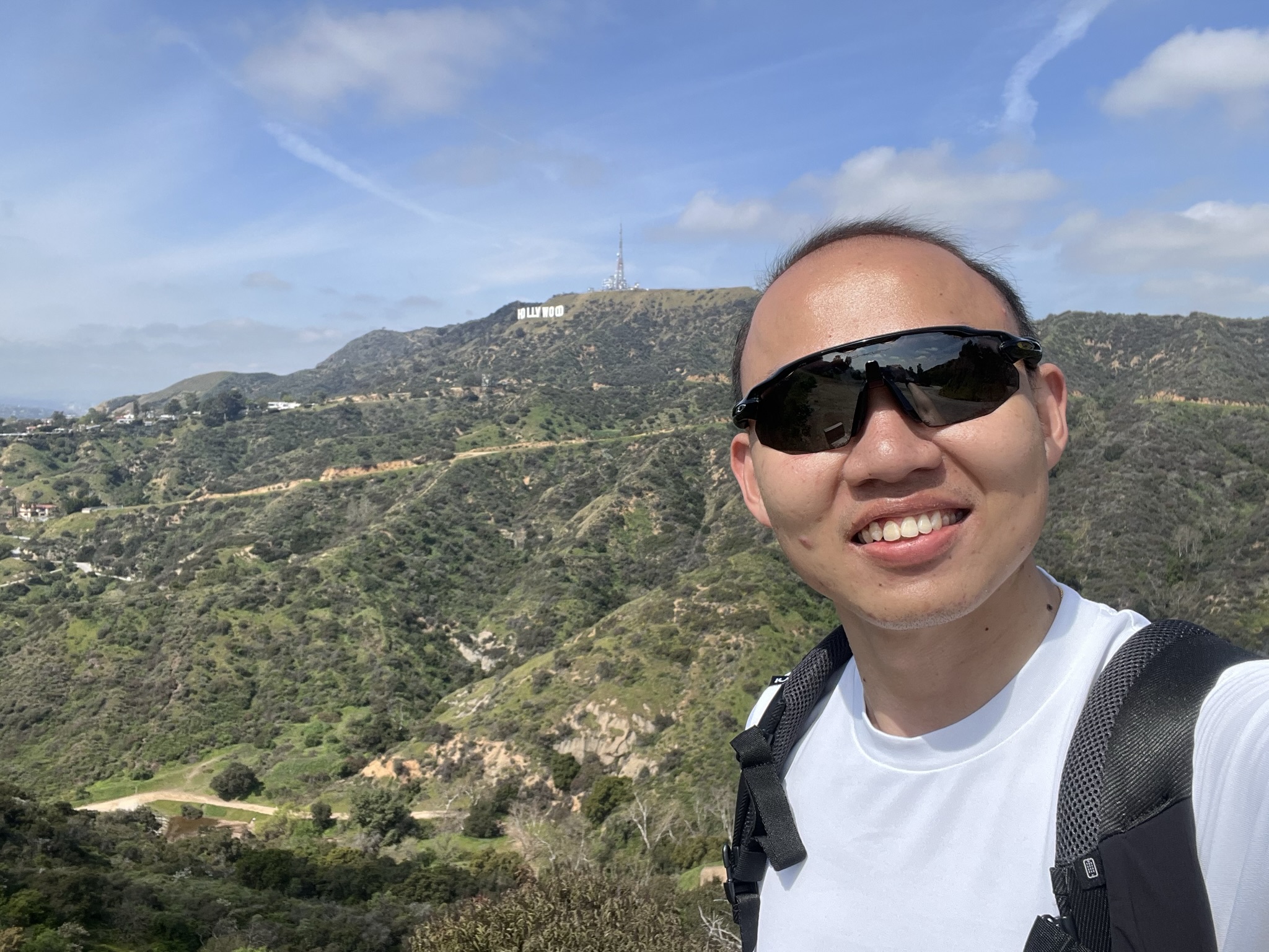
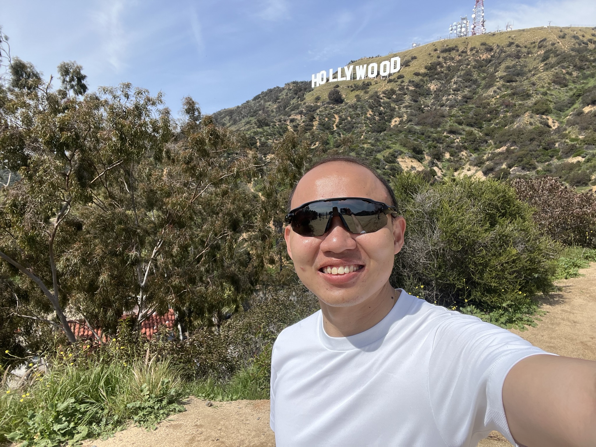
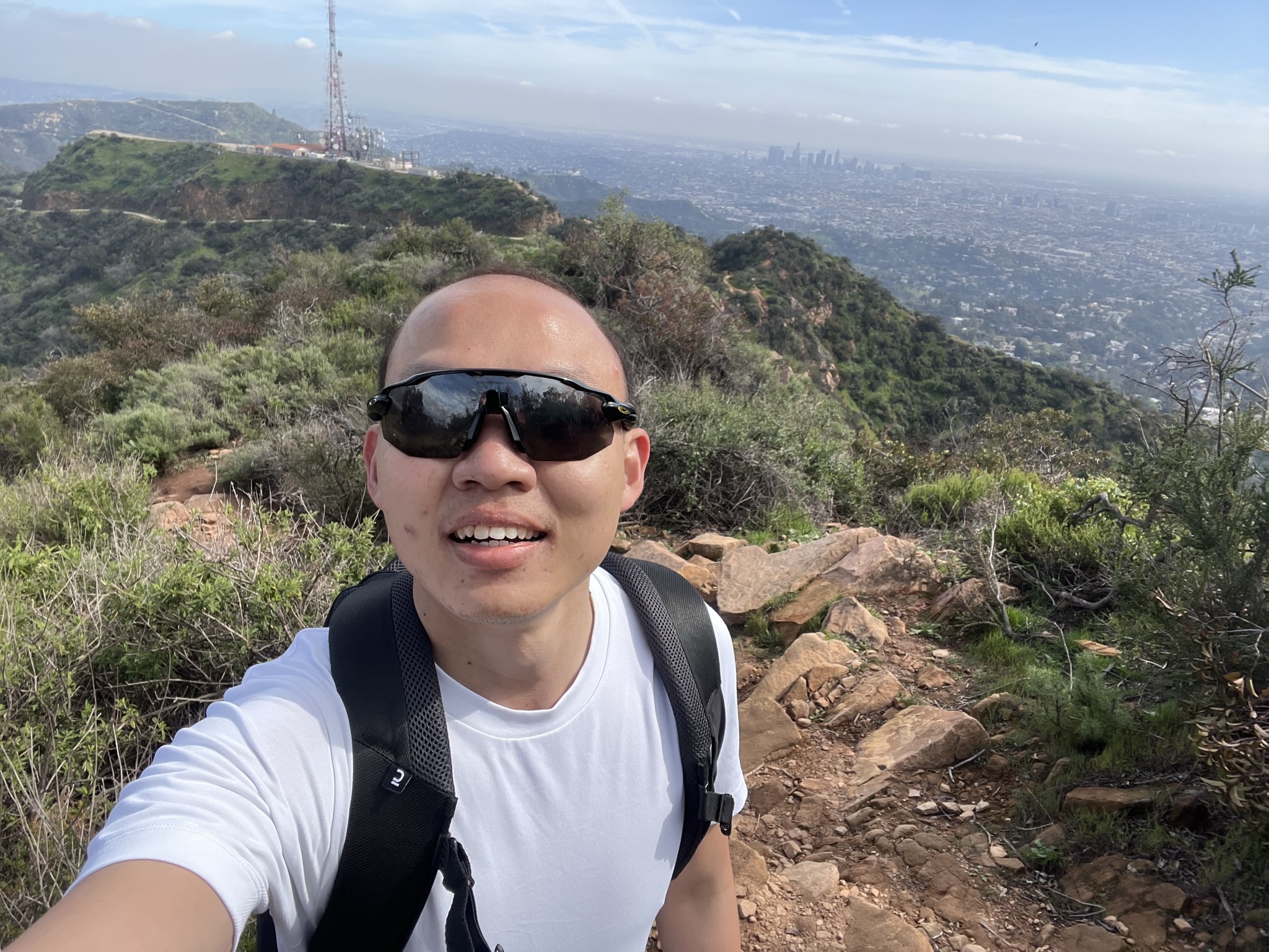
After a mile-walk, there was a T-junction as I was at Mt Lee Drive, in which going left got you to view point of the sign and on the right is to get behind it. I made left turn first and less than 10 minutes, there I was the closest possible to the front view of the iconic sign of Hollywood. To think it was first put up to promote local real estate development i.e. Hollywood Land and now became synonymous to the entertainment industry that I dare say that has taken over almost every big screen there is in the world. Did a quick photo op before returning back to the same junction as I decided to get behind the sign. Seeing where the locations where the signs were being erected, you would think the trail would be quite steep. You were right on that, though thankfully it was just a short while. Perhaps it was due to the fact I have been walking the whole morning and the energy that I had from morning brunch has been completely digested, I took a much slower pace going up the peak of Mt Lee. I could see the other cities of California on my right e.g. Burbank and at one point, I could see Universal Studio Theme Park as I recognised the Wizarding World of Harry Potter. Persevered, I made it to the top. I believe I have recorded at least 20k of steps to get up there. I refilled my energy bar with snacks (or more like bunch of chocolates) and finished my last drop of water. Dead.

Halo, it's me...
LA city was always with me.
Hey you. I'm getting behind you soon.
I believe that was Burbank behind me. Hi Ellen! Oh wait...
Made it!
That proud face that I can finally cross this off my list.

I hang around for about half an hour before searching how to get down. Another 'smart' decision. Thought of giving another trail a try without going back to where I came from, I went on ahead to Aileen Getty Ridge Trail whereby the trail was rockier than the previous, with little climbing needed. With LA view still on the left, I found myself unintentionally arrived at Wisdom Tree, saw it on the map before but wasn't part of the plan. The best part was there an American flag at the edge as I have been wanted to take with one but most of them weren't waving. It was windy. Seemed like a perfect closure for my Hollywood sign hike, which was no longer in sight, for now, I started my descent which got me to Wonder View Drive.

As you might notice, you couldn't actually get to the sign as it was fenced up and you are not allowed to cross it. From time to time, there was PA actually reminding people not to. I guess some visitors were just stubborn as there was police officer came by and called out some trespassers as I was leaving.
Rocky trail indeed it was. Hollywood Sign was where the telco tower was.
Needed to climb this but thankfully there wasn't much of it.
One with the flag.
One with Wisdom Tree. Hopefully I'm getting wiser now.
Half mile down. I was grateful I was getting down from here instead of going up.
Safely descended.
Can see what was I pointing at?

I can't seem to get any Lyft from where I was so I decided to make a walk along Lake Hollywood Drive and the next thing I know, I passed by Hollywood Reservoir, some fancy neighbourhood and reached Lake Hollywood Park, one of the view points of Hollywood sign that was mentioned in one YouTuber's video. It was around 4pm and there were people playing frisbee with their dogs, some guys with their footballs and a group of Asian having picnic, or making TikTok contents as I saw recording gadgets next to them. Getting myself replenished by buying myself a big cup of fruit and a bottle of drinking water while chilling at the park for about an hour. Initially plan to book a Lyft back to my AirBnB and I was happy at first that I managed to get a car but just to find out the previous passenger seemed to hold on to the booking as she was only doing a quick stop for photo and left in the same car. In other way, my booking was cancelled and I was trying to get another but to no avail. Reluctantly, I chose to walk further down to get to another pick up point which I hope I could hail another car but eventually I just decided to walk all the way back, 4.6 miles from the park, since I have done so much of walking anyway for the day so what is there to walk for another 1.5 hours. That was after I get my sugar level boosted at Station 76 at Franklin Avenue before finally getting back to cozy bed.

Seem to be rich people neighbourhood. Or the houses and streets are just good looking.
Last view point of today's journey.

The trail that I took might not entirely as what I planned but the best part was to explore the unforeseen and stumble upon the views that I didn't expect. I lost count of how many vantage points of Hollywood Sign for the day.


My trail of Hollywood Sign hike on 13th March 2023. Though I might say the trail ended at Lake Hollywood Park. Just all the best getting Lyft from there, or it wasn't my luck.

Saturday, 29 April 2023

USA Trip: Canyoning in Arizona & Catching David Blaine!

Grand Canyon, Arizona

When I found out that Grand Canyon was doable from Las Vegas via day trips or tours, I was very determined to make it happen. There were a number of national parks and canyon also within the vicinity such as Death Valley and Zion. After much contemplating and considering the time that I have in the States, I decided to include Antelope Canyon and I signed up for 2D1N package with MaxTour which cost 399 dollars for single occupancy. Made my booking 3 weeks before the actual day, this tour was one of my most anticipated itinerary.

One of the pick up points for other tour members. Saw this hotel during my search before deciding to stay at AirBnB eventually.

The day started as early as 4am as I needed to take a ride to El Cortez Hotel, nearby Fremont Street for 5.30am pick up as the tour only offered free pick up from hotels nearby The Strip and downtown. Thankfully Lyft was available in the early (or late hours) so I didn't need to walk the same path when I first arrived in Vegas. As I waited for my tour van, there was a police car pulled over another car right in front of the hotel. All the police scenes that I usually came across in the news started to flash in my mind, thinking what could happen next, just to see it ended well (or anti-climatically). The big van came and I was the first one onboard and we went on to pick up the rest before we continued on the journey. Free flow of snacks and drinks (bottled Starbucks included) were provided in the package. Picked up last passenger from MGM Grand, along with another family who didn't show up as per schedule at the previous hotel, we made our way to Hoover Dam as our first bonus stop.

The building of this dam believed to promote the growth of population in Las Vegas back in the 1930's by offering job opportunities during The Great Depression.

Crossing Nevada-Arizona state border at this point.

Admiring the desert of view of Arizona as we cruised along Route 93 before we arrived at Seligman, birthplace of the historic Route 66. It was a little township which gave old school cowboy town vibe. We did a quick stop at Motoporium for toilet break and there was mini exhibit of antique cars inside the store. When I thought I would no longer see snow after my trip at the far north, we were passing by stretches of the white matter before reaching Williams for lunch. Moving on further up along Route 64, we were getting closer and closer to the main destination of the day.

My Tour Van with the entourage. A Thousand Miles is playing in the background.
Hello, Route 66! Couldn't believe I get to step my foot at this iconic route.

One with the cars. There was no real explanation why these cars were here. Or is there?


This gave me Cruella Devil vibe, from 101 Dalmatians movie.

Couldn't leave this route without a photo, could I?
Lunch break at Pine Country Restaurant.

Little township of Williams. Our last stop before the main event.

We entered the park via South Rim of Grand Canyon and Yavapai was our first view point. Despite of the cloudy weather, it didn't dampen the magnificent view of the canyon. My breath was taken away as many times as I looked down and beyond which seemed to know no boundaries. During this time of the year, snow was visible which definitely icing on the cake, compensated the gloomy sky. We tracked along Rim Trail for different vantage points where the pathway was icy and slippery. Essentially there was no tracking required to get to these view points as there was proper concrete walkway for visitors with railing in place, with public restroom provided nearby. Bought myself few souvenirs at Yavapai Museum of Geology before being brought to Pipe Creek Vista, further down along South Rim. It was close to 6pm when we were at last view point before we decided to call it a day. It was getting dark as the sun started to set. Looking at the grandeur structure for one last time and we were brought to have our dinner at New York Teriyaki in the little township of Page. There were few options given by Joseph, our tour guide and everyone seemed to be opting for the same eatery. I started to get acquainted with another traveller during dinner who happened to be doing solo travel as well. We went on to check in to our hotel and rested for the night. Arizona has different time zone than California and Nevada, which is one hour faster. 

Standing at the precipice and in awe of this view.

"I am on the edge... of glory. The edge, the edge, the edge, the edge, the edge..."

Another viewpoint, with snowy sidewalks.

Model of Grand Canyon at Yavapai Museum.
One with the signage before moving to another check point. In case you couldn't see it or you were wondering, yes, it was raining.
View from Pipe Creek Vista.
One last shot with the canyon.

My stay for the night. 399 dollars seemed to be a very good bargain.

Lower Antelope Canyon, Navajo Nation & Horseshoe Bend, Arizona

Day 2 of the tour needn't to start as early since we were already nearby to our next point of interest. Breakfast was included but I decided to skip just to have a banana instead. The group gathered at hotel lobby around 8am and off we went to our first pitstop of the day, which was just 30 minutes away. This particular stop wasn't part of main highlight of this tour, at least for me, at least not in the beginning since the major driver was Grand Canyon. More so, for this particular excursion, additional 70 dollars was not included in the initial fee of 399 dollars. There were two reasons for this; the visit to Antelope Canyon was very much weather dependent and the tour would be cancelled should the forecast indicate heavy rain for the fear of flash flood. There was history of hikers being swept away as stream of water started to gush through the narrow channels and never been found or presumed dead, which made it mandatory only guided tour is allowed at the canyon. Secondly, the canyon is located at Navajo Nation whereby only Navajo is allowed to lead the tour, which explained the separate charge was to be paid separately to another agency. Lucky for us, the weather was on our side.

There were so many points of interest at this region. I'm seeing myself returning in the future just to check these off my list.

Each tour only allowed up to 10 pax and since my tour has extra member, I volunteered to join separate group, joining Italian tourists. The weather was rather gloomy with mild rain, fortunately it didn't get any heavier throughout the time we were there. I thought my guide was a serious dude with the stern look but turned out to have good sense of humour. The tour started with walking down very steep staircase towards the canyon, a slight slip could be fatal. Only photo taking was allowed within the canyon. I overheard the the other group guide (which was actually my original group) caught one of them recording video and asking him (or her) to delete it, else to leave the canyon. With that said, the rules were being enforced pretty strictly. No bagpack is allowed as well. Just before the tour started, Joseph taught us to configure the camera settings on phones so that could we capture the vivid colours of the sandstones walls as we would be going down of the canyon with limited lighting.

My tour guide on the left. Started to walk down to where the little shelter was, the starting point of the steep stairs.
View from the top looking down. Looking at the formation. You would be in for a treat.

One of the stairs within the canyon. Look at that steep stairways.

The trail was rather decent despite of the narrow pathways in which certain parts could only fit one person to go through. It wasn't a strenuous one-mile walk, with little stairs climbing here and there. I found myself in continuous amazement at every turn; you could stand at one spot with multiples perspectives, surrounded by the canyon walls. The same wall could have different impressions/interpretations from different angle. Our guide was very knowledgeable as he shared the history of canyon and showed us the sites that were used as wallpapers for TVs/mobile devices. Though right now, I wasn't sure which photo in my phone gallery is used for which wallpaper right now as there were all as pretty good pictures as the others. At one point he asked me how to pronounce seahorse in Malay (I told him I am from Malaysia) and subsequently he showed a formation that looked like one. For about an hour or so, we finally came to the exit of canyon. I thought we were supposed to tip the guide but ending up I didn't get to give any. I reunited with my tour group and we were off for next stop.

My first (of many) photo.

My tour guide helped me to take this photo,

and this...
and this. This is my current top photo of all time now.

Lady in the Wind. Can you see it?

Kuda laut. Seahorse. "Hai Ma". Weird coincidence that I'm working in the city with seahorse as its mascot.

Last selfie. As you can see, the tour groups were just keep coming and it would be very hard to take a lone photo inside the canyon. So, quick tip, be quick when there was no one around and of course, be considerate.

Horseshoe Bend, Arizona

We passed by the junction while we were on our way to the hotel the night before getting back from Grand Canyon. Walking through Arizona desert and could see crowd of tourists were already at the scenic view point of Horsehoe Bend. I bumped into some familiar faces that I saw back in Antelope Canyon, expected so since distance between the two was rather close. As the day went on, it started to rain albeit mildly but enough to soak myself wet. We were at the bend for about an hour before heading off to Big John's Texas BBQ for lunch break. We did one last stop to have overview of Lake Powell but the sky was totally overcast. We have one last group photo before heading our way back to Las Vegas, 4 hours journey ahead of us. At some point we crossed the state border and for a brief moment, we were in the state of Utah, before getting back to Arizona.

Walking towards the bend. Look at how the sky transitioned from left to right.
Leaving my footprint at this beauty.

Even the rain couldn't stop me from taking this selfie.

Me and Arizona's desert in winter.

Hearty lunch with this pork rib and a bottle of beer.

One photo with the tour group before going separate ways at the end of the day.

Quick stop in the state of Utah. So technically, I visited six states in this trip instead of five.

Scenic view of Route 15 as we were on our way back to the sin city.

Las Vegas, Nevada

Me and my newly-made friend requested to be dropped off right in front of Linq Promenade for dinner. We walked along The Strip, completely illuminated this time, towards Resort World to catch David Blaine show. I never knew David Blaine was still doing show and just happened he was having one when I was in Vegas. My friend only decided to join me when I told him on our way back to Vegas. The show started with David Blaine climbing up one of the scaffolding, around 80 feet high, before jumping off and landed onto pile of boxes. He needed medical emergency in which I thought was part of the gimmick when he mentioned that he dislocated his right shoulder until it started to get a little too long. He began asking for assistance from the audience in which there were doctors at least, if not specialist came to his aid. Some of the audience seem to lose their patience and decided to leave the hall. Despite so, the show went on as he managed to pop his shoulder back in, though still in slight discomfort. David told us we could just film/record the show if we wanted to, against the usual regulations that forbade us to do so.

He continued on with his acts, for some might be a bit too hard to stomach which involved sewing his mouth or piercing needles into his skin with volunteers from the audience came on stage to be his assistants. When I thought he submerged under water, holding his breath for 9 minutes would be the highlight but it was the final act that actually blown me away. Initially he asked a little boy to join him on stage and passed him deck of cards. Some of the audience, myself included have similar decks at our seats and was given instructions to shuffle the card as how we wanted to, randomly. What is the odd that when he asked to draw out the last card, everyone was showing four of hearts in their hands, including the boy's. Totally mind "eff-ed" for a while. The whole show lasted for about 2 hours. It was beyond my initial plan that I could catch David Blaine show, which was a nice conclusion of my last weekend in the States. Retrieved our bagpack, we bade farewell to each other and returned to respective stays.

My last dinner in Vegas at Off The Strip.
Waiting for the show to start.

David's opening act. Moment before he dislocated his left shoulder.

Snippet of David Blaine's attempt holding his breath under water for 9 minutes and he did!

The last card that everyone drew out for David's last act. Still mind blown on how he did it.

Last night in Vegas. Was waiting for my Lyft after sending my friend off to his hostel.

One last city to go.